Power Plant Emissions from Remote Sensing Imagery
Project Details
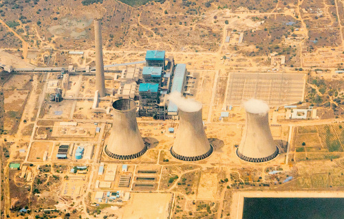
Background: This project with WattTime aims to estimate carbon emissions from all large power plants worldwide using satellite imagery. The images come from a variety of satellites, sensors, and wavelengths that observe power plants at different times and capture different properties.
Challenge: We are limited by the revisit times of satellites, low spatial resolution, and partial occlusion from clouds. Our models must also generalize from countries with recorded emissions on which we can train to all power plants globally. Remote sensing images are quite different than everyday photographs. They contain different types of objects and textures, vary in appearance from one satellite to another, and have more than three color channels.
Solution: This project is still ongoing, but our efforts so far have focused on visible signals from power plants: vapor plumes emitted from cooling towers, mechanical cooling, and emissions control technology. We developed deep learning models that focus on the sources of these signals to predict whether a plant is on or off and estimate its current generation. These predictions are aggregated across different models and satellites, as well as over time, to produce emissions estimates for each plant.
Press Release 2019
Forbes
Press Release 2020
IEEE Spectrum
Time Best Inventions of 2020
Climate Change AI Workshop @ NeurIPS 2020
Duke Energy Data Analytics Symposium
Google Sustainability Video
Quartz
COP28: Al Gore and Climate TRACE Unveil Game-Changing Greenhouse Gas Emissions Inventory
Science
YouTube: Al Gore and Gavin McCormick unveil unprecedented Climate TRACE emissions data at COP29
MDPI: Estimating Carbon Dioxide Emissions from Power Plant Water Vapor Plumes Using Satellite Imagery and Machine Learning